


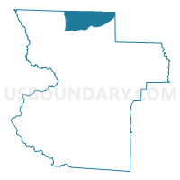
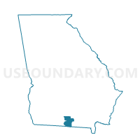
18504 - MT OLIVE CHURCH Voting District, Lowndes County, Georgia
About
Outline

Summary
| Unique Area Identifier | 562414 |
| Name | 18504 - MT OLIVE CHURCH Voting District |
| County | Lowndes County |
| State | Georgia |
| Area (square miles) | 22.33 |
| Land Area (square miles) | 21.99 |
| Water Area (square miles) | 0.34 |
| % of Land Area | 98.49 |
| % of Water Area | 1.51 |
| Latitude of the Internal Point | 31.00093320 |
| Longtitude of the Internal Point | -83.26343220 |
Maps

Graphs
Select a template below for downloading or customizing gragh for 18504 - MT OLIVE CHURCH Voting District, Lowndes County, Georgia


Neighbors
Neighoring Voting District (by Name) Neighboring Voting District on the Map
- 0191144 - RAY CITY Voting District, Berrien County, GA
- 0191329 - LOIS Voting District, Berrien County, GA
- 075C - CECIL Voting District, Cook County, GA
- 1731 - LAKELAND Voting District, Lanier County, GA
- 18503 - HAHIRA UNITED METHODIST Voting District, Lowndes County, GA
- 18507 - PINE GROVE CHURCH Voting District, Lowndes County, GA
Top 10 Neighboring County Subdivision (by Population) Neighboring County Subdivision on the Map
- Adel-Sparks CCD, Cook County, GA (15,061)
- Hahira CCD, Lowndes County, GA (14,844)
- Barretts CCD, Lowndes County, GA (13,021)
- Lakeland CCD, Lanier County, GA (8,142)
- Ray City CCD, Berrien County, GA (3,500)
Top 10 Neighboring Unified School District (by Population) Neighboring Unified School District on the Map
- Lowndes County School District, GA (54,715)
- Berrien County School District, GA (19,286)
- Cook County School District, GA (17,212)
- Lanier County School District, GA (10,078)
Top 10 Neighboring State Legislative District Lower Chamber (by Population) Neighboring State Legislative District Lower Chamber on the Map
Top 10 Neighboring State Legislative District Upper Chamber (by Population) Neighboring State Legislative District Upper Chamber on the Map
Top 10 Neighboring 111th Congressional District (by Population) Neighboring 111th Congressional District on the Map
Top 10 Neighboring Census Tract (by Population) Neighboring Census Tract on the Map
- Census Tract 102.02, Lowndes County, GA (11,096)
- Census Tract 9502, Lanier County, GA (8,142)
- Census Tract 101.02, Lowndes County, GA (5,348)
- Census Tract 9604, Cook County, GA (4,700)
- Census Tract 101.01, Lowndes County, GA (4,321)
- Census Tract 9706, Berrien County, GA (3,500)